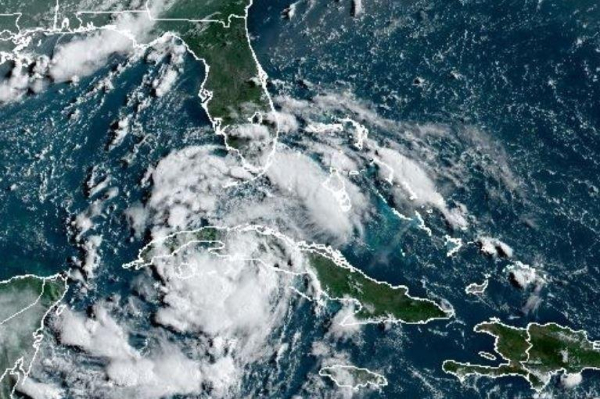

Tropical Depression 4 was moving past Cuba and along the Gulf of Mexico with the storm forecast to become tropical storm Deby later Sunday. Image courtesy National Oceanic and Atmospheric Administration
Tropical Depression 4 was moving past Cuba and along the Gulf of Mexico on Saturday with the storm forecast to become tropical storm Debby on Sunday.
In the 8 a.m. update from the National Hurricane Center, the depression was about 75 miles south of Veradero, Cuba, and about 170 miles south of Key West, Fla. The storm had maximum sustained winds of 30 mph and was traveling west-northwest at 16 mph. Advertisement
The depression is forecast to strengthen into a tropical storm, with the threshold 39 mph.
NHC is predicting a turn toward the northwest, followed by a northward motion on Sunday and then a slower northeastward motion Sunday night and Monday
“As the tropical depression pulls away from Cuba and then moves over the eastern Gulf of Mexico on Saturday, we expect it to gain strength and become a tropical storm,” AccuWeather Lead Hurricane Expert Alex DaSilva said.
Water temperatures over the eastern Gulf of Mexico are in the mid to upper 80s.
A hurricane watch was issued for parts of Florida’s Big Bend region, Aucilla River to Yankeetown, an area in southwest Florida still recovering from a devastating blow Category 3 in Idalia last August. Advertisement
A tropical storm warning is in effect from the Florida Keys south of the Channel 5 Bridge and west of the Aucilla River to the Ochlockonee River.
A storm surge watch is in effect for Bonita Beach northward to the Aucilla River, including Tampa Bay and Charlotte Harbor.
At least one tornado is possible across the Florida Keys and the western Florida Peninsula tonight through Sunday morning, NHC said.
“The regional hurricane models and statistical guidance continue to indicate some potential for the system to reach hurricane strength before it makes landfall in the Florida Big Bend region, NHC forecaster Amanda Reinhart said.
After landfall Monday, the storm is forecast to track to the northeast over portions of northern Florida and southern Georgia.
The storm is expected to produce rainfall totals of 5 to 10 inches, with maximum rainfall totals up to 15 inches.
Previous storms were Tropical Storm Alberto, Hurricane Beryl and Tropical Storm Chris.
In the Pacific, Hurricane Carlotta, a Category 1 storm, is about 645 miles west-southwest of the southern tip of Caja California with maximum sustained winds of 90 and moving west at 14 mph.
NHC, in its 2 a.m. PDT update, forecasts a slower westward to west-northwestward motion during the next few days. Advertisement