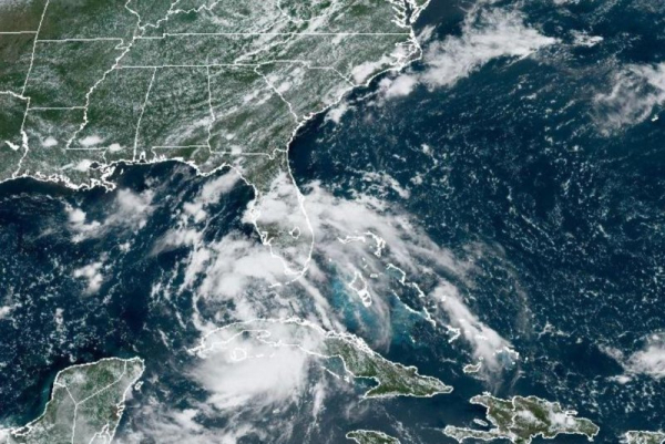

1 of 2 | Tropical Depression 4 was moving past Cuba and along the Gulf of Mexico with the storm forecast to become tropical storm Debby by Saturday. Image courtesy National Oceanic and Atmospheric Administration
Tropical Storm Debby continued to strengthen in the Gulf of Mexico after emerging Saturday afternoon, already causing some tropical storm-force winds in the Florida Keys.
The storm is expected to become a hurricane by Sunday night before making landfall Monday with “potentially historic” rainfall. Advertisement
In its 8 a.m. update, the National Hurricane Center said the storm has maximum sustained winds of 60 mph and is about 155 miles southwest of Tampa.
The storm continues to gradually turn to the right and forecasters have high confidence that the core of the cyclone will reach the Big Bend region of Florida by early Monday morning.
“While Debby moves across the very warm waters of the eastern Gulf of Mexico and remains in a relatively low wind shear environment, the storm will have an opportunity to strengthen rapidly before reaching the coast,” the NHC said.
Water temperatures over the eastern Gulf of Mexico are in the mid to upper 80s, according to forecasters. Warm ocean waters, typically above 79.7 degrees, provide the necessary heat and moisture that cyclones need to form and then fuel their growth.
“The reliable intensity models all suggest significant strengthening, and the degree of intensification will be most related to how quickly Debby develops an inner core,” the NHC said. Advertisement
Forecasters are predicting a “significant flooding event” caused by the slow-moving speed of the storm and its erratic movements, as well as heavy rainfall.
A hurricane warning was issued for the Florida Gulf Coast from the Suwannee River to the Ochlockonee River. A hurricane watch is in effect for the Florida coast, from west of the Ochlockonee River to Indian Pass and from east of the Suwannee River to Yankeetown.
A tropical storm warning is in effect from the Florida Keys west of the Seven Mile Bridge, including the Dry Tortugas, and the west coast of the Florida peninsula from south of Yankeetown to East Cape Sable.
A tropical storm watch stretches from Florida Keys north of the Seven Mile Bridge to the Channel 5 Bridge, and the Florida coast west of Indian Pass to Mexico Beach.
A storm surge warning is in effect from Florida Keys west of the Seven Mile Bridge including the Dry Tortugas, to the west coast of the Florida peninsula from south of the Suwannee River to East Cape Sable.
Florida Gov. Ron DeSantis declared a state of emergency on Thursday night in 61 of 67 counties.
At least one tornado is possible across the Florida Keys and the western Florida Peninsula tonight through Sunday morning, NHC said. Advertisement
After landfall, weakening steering currents should cause the cyclone to slow down while it moves northeastward or eastward over parts of northern Florida and southern Georgia.
The storm is expected to produce rainfall totals of 6 to 12 inches, with maximum rainfall totals up to 18 inches across portions of Florida and across the U.S. coast through Thursday, according to NHC.
Previous storms were Tropical Storm Alberto, Hurricane Beryl and Tropical Storm Chris.